LDMG - Advice No. 2 - October 5 2022 - 1.30pm

LOCAL DISASTER MANAGEMENT GROUP - ADVICE NO. 2
5 October 2022 - 1.30pm
This is an update from the Local Disaster Management Group (LDMG) for the Balonne Shire. Residents are asked to prepare now, stay informed and monitor conditions and where possible avoid travelling into areas that will be most affected.
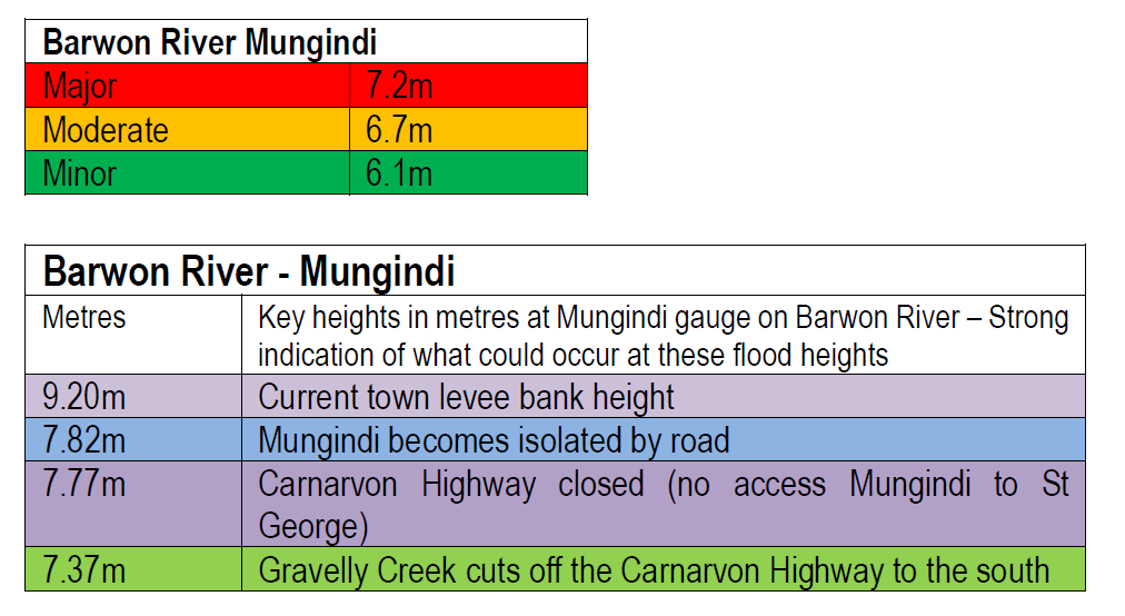
MUNGINDI
HEBEL
There is currently a minor flood warning on the Balonne River system with the Bokara River at Hebel currently at 1.05m.
ROAD UPDATES
Road conditions in the Balonne Shire are expected to change without notice. Areas of concern include the Castlereagh Highway for residents between Dirranbandi and Hebel. The conditions are very likely to impact travellers heading in and out of New South Wales across our border towns of Hebel and Mungindi (Carnarvon Highway south to Moree) with significant rain forecast in Northern and Central West New South Wales. Other parts of our Shire may also be impacted with local road closures depending on the rainfall. Current road conditions are:
- Carnarvon Highway open to Mungindi
- Castlereagh Highway (Dirranbandi - St George) open
- Castlereagh Highway between Hebel and Dirranbandi open
- Carnarvon Highway to Roma is open
- Moonie Highway – Open
Remember road conditions can change without notice Council will continue to provide updates utilising Council's Emergency Dashboard
NEW WARNING SYSTEMS
You will note at the top of this bulletin we have added the following warning icon. The new warning levels are changing across Australia to provide consistent messages to people and what actions they may need to take no matter their location.
There are three warning levels:
Advice (Yellow): An incident has started. There is no immediate danger. Stay up to date in case the situation changes.
Watch and Act (Orange): There is a heightened level of threat. Conditions are changing and you need to start taking action now to protect you and your family.
Emergency Warning (Red): An Emergency Warning is the highest level of warning. You may be in danger and need to take action immediately. Any delay now puts your life at risk.
GENERAL UPDATES
Residents should consider what they need to do to ‘Get Ready’ for the upcoming wet season. Do you have sufficient supplies at home if you become isolated. Do you need to reconsider your travel arrangements. More information can be found at www.getready.qld.gov.au including tips on your insurance policies and preparing your own ‘get ready’ plans.
Residents can stay up to date by subscribing to Council's Emergency Dashboard for all the latest weather and road conditions. The dashboard includes links to www.bom.gov.au/qld and QLD Traffic. For more information phone Council on (07) 4620 8888 - this includes after-hours service.
In an emergency dial 000 or SES on 132500. For more information phone Council on (07) 4620 8888 - this includes after-hours service.
Remember if its flooded forget it.
Councillor Samantha O’Toole
CHAIR - LOCAL DISASTER MANAGEMENT GROUP